

")
- You are here:
-
Home

-
Fields of...
- geology
Geology
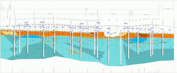
The "Geology" sector is mainly aimed at engineering geology problems such as "geological and hydrogeological risk assessments" and "environmental impact assessments".
Engineering geological zonings of the territory are drawn up taking into consideration hydrogeological instability and landslide risk. The results of these studies are used in the preparation of town zoning regulations and databases.
Geological, geomorphological and hydro-geological reports are written as integral part of the design of potential high-risk engineering works (e.g. pipelines and dams) or as propaedeutic studies in the definition of railway, road and highway layouts.
More in detail, the activities include:
- geological feasibility studies on a large scale;
- geological site definition by site investigation and data processing;
- instability studies on a territorial scale and detailed landslide studies on a local scale;
- database implementation;
- water supply and phreatic aquifer potential assessments;
- road, railway and pipeline layout studies;
- research of construction materials; finding, valuation and exploitation planning of aggregate and rock quarries;
- location studies and support studies to the design of high environmental risk works (e.g. dams, waste disposal systems, pipelines);
- geological and tectonical studies developed at different scales as part of seismic zonation studies;
- site geognostic investigation supervision;
- geological and geostructural surveys;
- mathematical and hydrogeological models.